ArcGIS Parcel Fabric

ArcGIS Pro Parcel Fabric
At the 2019 Esri User Conference in San Diego, Esri released the next generation of Parcel Management Tools - the ArcGIS Parcel Fabric. The ArcGIS Parcel Fabric provides a faster, more flexible solution that uses a less restrictive data model than the previous ArcMap Parcel Fabric and allows the immediate use of a record driven workflow without extensive clean up of your data.
The Parcel Fabric
The Esri Parcel Fabric is a specialized component of Esri's ArcGIS software suite designed for the management and maintenance of cadastral and parcel data within a geographic information system (GIS) environment. It provides tools and capabilities to store, edit, analyze, and visualize parcel information, enabling organizations to effectively manage land records, property boundaries, and related attributes and includes the following key components and functionalities:

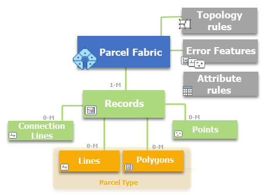
The Parcel Fabric Data Model
Parcel Data Model:
The Parcel Fabric utilizes a robust data model specifically designed to represent the spatial and non-spatial attributes of parcels. It supports the storage of parcel geometry, survey data, ownership information, rights-of-way, easements, subdivisions, and other relevant details associated with land records.
Data Editing and Maintenance:
The Parcel Fabric offers a set of editing tools that allow users to create, modify, and maintain parcel data. Users can update parcel boundaries, adjust parcel dimensions, split or merge parcels, and manage survey data. The editing workflows help ensure data accuracy and integrity.
Integration and Data Exchange:
The Parcel Fabric supports data integration with other GIS datasets and external data sources. It allows users to import or export parcel data in various formats, facilitating interoperability with external systems and data providers. This enables organizations to integrate parcel data with other spatial and non-spatial datasets for comprehensive analysis and decision-making.
Versioning and Historical Tracking:
The Parcel Fabric incorporates versioning capabilities, allowing users to track changes made to parcel data over time. This feature enables the management of historical records, maintains an audit trail of edits, and supports the ability to view past configurations and states of parcel boundaries.
Topology and Data Validation:
The Parcel Fabric includes tools for managing the topological relationships between parcels. It supports validation rules to ensure data quality and integrity, detecting and correcting common errors such as overlapping parcels, gaps, and inconsistent geometry.
Visualization and Analysis:
The Parcel Fabric integrates with the broader capabilities of ArcGIS for spatial analysis, visualization, and querying of parcel data. Users can perform spatial queries, generate thematic maps, conduct spatial analysis, and create reports based on the parcel attributes.
Workflows and Automation:
The Parcel Fabric provides workflow management capabilities to streamline common parcel management tasks. Users can define and automate workflows for data review, quality control, and approval processes, enhancing efficiency and reducing manual effort.
Results
By utilizing the Esri Parcel Fabric, organizations can effectively manage and maintain their cadastral and parcel data within a GIS environment. It provides a comprehensive set of tools and functionalities for data editing, integration, validation, analysis, and visualization, enabling efficient land record management and supporting decision-making processes related to land administration, real estate, planning, and related fields.
Want to learn more about the Parcel Fabric?
If you are interested in exploring the next generation of Parcel Mapping, please reach out and contact us and we will prototype a portion of your data to help you experience how much better parcel mapping is in the Parcel Fabric.
If you are looking for more information about the. Parcel Fabric, what is needed for conversion to the Parcel Fabric or try it out on a prototype, please use this link to contact us a nd we will be happy to help you.


